Tithe Map and Awards
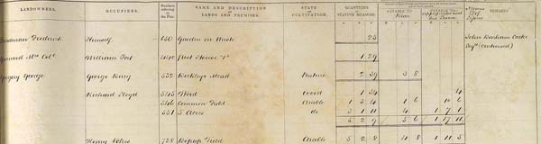
Extract from the Tithe Awards for East Meon
In 1852/3, East Meon was surveyed as part of the national assessment scheme entitled the Tithe Apportionments. Every building, field, wood and yard in the parish was mapped and measured. The owners, tenants and occupants were listed, as were the tithes paid to the vicar and the rents to the landlords.
In this section are details from the Tithe Apportionment maps and a spreadsheet of the entries in the Awards relating to East Meon. The original manuscript of the entries is in our Library on a DVD, and are the property of the Hampshire Record Office,. (The History Group transcribed the entries.)
Tags
Browse by century:
- 25th (1 result)
- 26th (1 result)
- 1st (1 result)
- 2nd (1 result)
- 3rd (1 result)
- 4th (1 result)
- 5th (1 result)
- 6th (1 result)
- 7th (1 result)
- 8th (2 results)
- 9th (7 results)
- 10th (7 results)
- 11th (27 results)
- 12th (24 results)
- 13th (23 results)
- 14th (37 results)
- 15th (34 results)
- 16th (40 results)
- 17th (47 results)
- 18th (58 results)
- 19th (111 results)
- 20th (277 results)
- 21st (155 results)


No Comments
Add a comment about this page